Saturday, August 27, 2011

Hurricane Irene Update with approximate Timeline


Heavier rain bands are moving through northern NJ now and Irene's center is still located just east of Ocean City, MD.  Hurricane Hunter aircraft investigating Irene's center shows that minimum pressure has increased very slightly to 955mb signifying some weakening.  This was expected to occur; however, Irene is still on track to remain a hurricane through the next 12 hours, as she passes over NYC metro.  I do believe Irene will follow a path closer to the Jersey coastline, if not over it, and continue NNE over Manhattan/Brooklyn/Nassau County borders. 

As I mentioned at the top, the heavier rain bands have begun to push through the region and some of these bands are producing TORNADOS.  North NJ can expect much of the same over the next couple of hours. Between 1AM-5AM, tropical storm force sustained winds between 30-60mph will be wide spread throughout the region with higher wind gusts located in heavier rain bands.  Around 5AM, Irene's core will be close enough to bring us hurricane force sustained winds ranging upwards near 80mph.  That will last until 10AM, at which point, the winds will begin to gradually subside.  

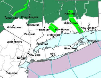
Flooding is the other concern. Reports at this early hour of the storm are coming in from Newark and Jersey City of street flooded.  Because of the saturated rain, it was estimated that only 2" of rain would be needed to flood much of NJ and we are already at that point.  Forecasted rain totals throughout NJ are between 8"-12".  Widespread flooding is expected and that's not including the storm surge and storm tide levels along the coast.  Storm surge forecasts are calling for 4'-8' from Cape May to Long Island Sound.  Raritan Bay can expect 6' storm surges; Battery Park can expect 5' storm surge; and Atlantic City could see storm surge of around 8'.  Water levels rising 4'-6' plus another 2'-4' associated with the New Moon Tide gives us a storm tide range of 6'-10'.  So imagine the water levels along the coastal regions rising 6'-10' plus 10'-15' waves crashing above that!  This is a very serious threat to public and property so if you decided to stay along the coast and not heed the evacuation orders, climb as high as you can and hope for the best.  

As long as you have power, please keep watch for tornado warnings posted for your area and stay away from windows in case any debris gets whipped around.  Also, for those living near tall trees, I suggest staying in a lower level of your house, in case a tree falls.  If you happen to lose power, which much of us will, please refrain from using candles! Candles present a severe fire threat and emergency vehicles will not be out to help during the peak of the storm.  With that said, I wish you all the best. 

Friday, August 26, 2011

Hurricane Irene approaching NC Coastline, still forecasted to strike NJ/NYC Sat/Sun

Hurricane Irene appears to be weakening slowly as it approaches the NC Coastline. She remains a Cat 2 hurricane with 100mph sustained winds and gusts upwards of 115mph.  Hurricane WARNINGS are posted from Little River Inlet, SC to Sagamore Beach, MA, encompassing 29 million people!
Hurricane Irene has stabilized and the minimum pressure has actually dropped slightly, which could be a sign of some minor strengthening.  Once she crosses the NC coast, Irene will continue to weaken to a Category 1 storm by the time it reaches NYC. That's good news, right? NOT QUITE! Yes, it is good that the max winds have decreased; however, this storm is so massive and the wind field so expansive that the effects will be widespread, prolonged, and destructive.  Storm surge along the Jersey Shore and Raritan Bay will be in the 5'-10' range.
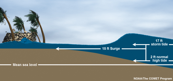
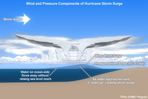
For those of you who do not know what storm surge is, let me take a minute to explain. Some people believe it is simply flooding. Storm surge is much more dangerous than simply flooding.  Storm Surge is defined as the abnormal rise of water from a storm, over and above the predicted astronomical tide level. Storm TIDE is defined as the combination of storm surge and astronomical tides. See the picture to the right for further explanation. Storm tides could reach 12'-15' along the coast during high tide Sat/Sun, as the astronomical high tide will be abnormally high due to the new moon phase.  Unfortunately, the peak storm surge for Irene is expected to occur during the morning high tide along the coastline. Historically, more people have died and property damage destroyed from storm surge than the wind.

Worst case scenarios in NYC call for up to $50-$100 billion in damages.  Storm surge associated with this storm could flood the Holland and Brooklyn Battery Tunnels, lower Manhattan, and could leave JFK Airport under 10'-20' of water! 

Thursday, August 25, 2011

Incredible Footage Taken from ISS of Hurricane Irene

Check out this video taken by cosmonauts on the International Space Station as they flew 230 miles above Hurricane Irene. This storm is incredibly massive and equally as dangerous. Irene is actually over 1,000 miles across!!! Video courtesy of NASA


Wednesday, August 24, 2011

Hurricane Irene Updates beginning Thursday Aug 25

After following tropical storms for so many years, I've quickly learned that tropical forecasts are very dynamic and tend to shift at every model run. Therefore, I decided to hold off on posting blog updates until the moment of land impacts were at hand. Well, the outer-most cloud bands of Irene are only a few miles off the coast of Florida this evening and she will begin to turn north Thursday afternoon. As she does so, we'll have a much better idea of her future impacts.
Those either living in or traveling to Long Island, the Jersey Shore, or the New York Metro area need to pay very close attention to Hurricane Irene and this blog! 


Wednesday, June 22, 2011

*TORNADO WARNING*

UPDATE*** 


_______________________________________________________________________________

A TORNADO WARNING has been issued by the NWS Morris, Hunterdon, Sussex, and Warren Counties. Doppler Radar indicated a possible tornado associated with a supercell thunderstorm pushing through NW NJ. Take precaution and be careful if you must travel through this storm's path.
The velocity scan below for this cell shows a clear rotation beginning at 30,000ft. This is a very dangerous storm and needs to be taken seriously.
It is moving ESE at 23mph through Sussex and Warren Counties toward Essex County. Budd Lake, Mount Olive, East Hanover, and Livingston areas need to be on high alert!

Wednesday, June 8, 2011

RECORD HIGH!

Temperatures in and around the Newark area reached into the upper 90s this afternoon.  In Newark, the temperature climbed to a record 99 degrees! That surpassed the previous record of 97 degrees, which occurred twice before (1999 & 1984).  Average highs for this week are typically in the high 70s.  However, these record temperatures will continue into tomorrow.  Forecasts are calling for temperatures to be even higher if only by a few degrees.  Urban locations will experience higher temperatures due to the Urban Heat Island effect.  Heat advisories are still ongoing and will remain in place thru 8pm tomorrow evening.
The good news is that relief is in sight.  A cold front will push through the region tomorrow night.  Strong thunderstorms capable of producing damaging hail, strong winds, and even the threat of an isolated tornado or two.  Stay alert and listen for any warnings posted as these storms approach from the west. 
In the meantime, try to stay cool by drinking plenty of water and keeping out of the sun.

Monday, June 6, 2011

I'm a Weatherman....


Ok so I happened to stumble across this and couldn't stop laughing! I finally have a theme song of my life! haha The meteorologist in the video is former KBTV meteorologist Nick Kosir, also known as the Rapping Weatherman.

Anyway, we have a whole lot of heat in store for us over the next few days. Expect record heat on Wednesday, with temperatures possibly climbing close to 100 degrees! We also may very well have our first tropical cyclone in the Pacific off the coast of Mexico by tomorrow morning and another storm is worth keeping an eye on near Jamaica and Cuba.
Stay Tuned!

Thursday, June 2, 2011

Record Tornado Season continues to amaze!

Last week, we witnessed severe storms in the midwest powerful enough to produce several EF-4 and EF-5 tornados.  Yesterday, severe thunderstorms developed ahead of a cold front in the northeast and produced two tornados which claimed the lives of 4 residents in Massachusetts.  The two tornados in the Springfield area have been classified at least an EF-2 with winds between 110-137 mph.  These storms were fueled by record breaking heat along the I-95 corridor from Washington, DC to Newark and even Burlington, all of which set records earlier in the afternoon.  Below is a youtube video which shows the dramatic footage of one of the Springfield tornados as it moved south over the river, paused, then shifted back east and over the city.  


There isn't much good news to come from storms like these; however, just so we can establish some form of a silver lining, following these storms came a much needed cooler air mass.  Today, we saw temperatures drop into the mid to upper 70s along with a cool breeze.  Tonight, temperatures will fall into the upper 40's under clear skies.  Frost advisories have even been issued for the Alleghany Plateau in west New York and Northern Pennsylvania.  Temperatures will remain in the low 70s Friday before climbing back into the 80s, just in time for a weekend at the shore.

I'm Back!

Ok so I've been away for some time now. Unfortunately, I've been a little preoccupied with other obligations and I apologize to those who check this blog regularly. But I'm glad to report that I'm going to be updating this blog as often as I can. Now that summer is at hand, it means I will be covering severe weather outbreaks as well as tropical weather! Later today I will be posting a blog concerning the tornado outbreaks, as well as, a couple of tropical disturbances worth keeping an eye on for further development in the Gulf of Mexico and Caribbean.

STAY TUNED!

Sunday, February 20, 2011

Old Man Winter Is Back!

UPDATE 1:45 AM: After looking at the radar for the last couple hours, a pocket of dry air has built up over northeast NJ and much of the precipitation moving over the area is evaporating before it reaches the ground.  The longer this dry air remains, the lower our snow totals will be for this storm.  I'm not ready to lower the forecasted snow totals just yet; however, if this dry air remains for another hour than we can expect totals in the 2"-4" range instead of the previously forecasted 4"-6".


Well, that springtime feel we had last week is gone and now another winter storm is at hand.  Overnight tonight, a string of low pressures from the midwest will being pushing through bringing with it a steady stream of snow and possibly sleet during the afternoon.
The first storm will come in tonight with snow beginning between 12am-2am.  During the overnight hours, the snow will become heavy at times.  By noon, we could see some brief mixing with sleet particularly over the urban areas of northeast NJ.  This could keep snow totals on the lower end of the forecast range.  Snow should begin to tamper off around 2pm-4pm; however, by this point there will already be 4"-6" of snow on the ground.  The further west you are, the more snow you will accumulate.
The second round will come in on Tues; however, at this time, my belief is that this storm will be too far south to impact North Jersey's weather.  This storm will have a greater impact on south Jersey.  If anything changes in this storm's path I will be sure to post an update.

Remember, snow total graphics courtesy of the NWS are accessible on the Forecast page.  Don't forget to follow the precipitation moving through the area on the Radar page as well!

For now, enjoy yet another round of winter weather.  Only a few more inches away from a record breaking seasonal snow total!

Friday, February 4, 2011

Another Coastal Storm for Saturday

I understand we are all growing tired and agitated with this carousel of storms this winter, but, just remember, I do not control the weather. I simply analyze it.

Now that I tried to protect myself, let's get down to it. There's yet another coastal storm moving up the coast this weekend.  The good news is that the storm is forecasted to hug the coast.  This is a good thing because the storm will not be able to tap into as much moisture as possible and therefore it won't be able to "bomb out" and become a powerful winter storm.  Also, it will allow more warm air to filter into the area.
Now, light snow will begin to move into the area very early Saturday morning. By late morning, as temperatures begin to climb to the low 30s, the snow will begin to mix with sleet and rain.  The low pressure center will be off the coast of NJ by mid afternoon, at which time, the warmer air will be moving into the region, allowing for a changeover to rain.  This will keep our snow totals down.  We are looking for a light snowfall with this storm and some minor icing, primarily before the changeover to rain.  Much of north Jersey will see snow totals between 1"-3". The further east you are, the lower the snow totals for this weekend.  Sussex and Warren counties will have a greater chance of minimal ice accumulation as they will most likely not see any rainfall, but rather, a longer period of snow/sleet.

As a side note, we are only 18" away from having the snowiest winter on record for the NYC metro area! More on that to come next week.

Tuesday, February 1, 2011

UPDATED Ice Storm Warnings posted

UPDATE: Ice storm warnings extended through much of Northern NJ except for the coastal regions.  The Winter Weather Advisory has been upgraded to a Freezing Rain Advisory. The only reason the Ice Storm Warning wasn't extended into the urban and coastal areas is because a changeover to rain is expected Wednesday morning.


As of 11:30am this morning, the National Weather Service cancelled the Winter Storm Warning for Essex, Union, Bergen, Passaic, and Hudson counties.  That's the good news.  The bad news is Western Essex, Western Union, Bergen, and Passaic counties were issued an Ice Storm Warning; while, Eastern Essex, Eastern Union, and Hudson counties were issued a Winter Weather Advisory.  An Ice Storm Warning is issued for a 1/2 inch or more of ice accumulation which causes damage to power lines and trees.  They are only issued when there is high confidence that the entire storm event is expected to be ice.   The reason some of the area is only issued a Winter Weather Advisory is because the forecasted accumulations fall just short of any watch or warning criteria and will be a mix of precipitation.  Conditions will still be dangerous in the advisory area, as ice accumulations of .25" to .40" is expected.

The first wave of this storm has come and gone with a very minimal impact for northeast NJ.  We woke up to just an inch or so on the ground.  The second wave will be more powerful and should begin moving in after midnight tonight.  Temperatures at the surface will be well below freezing, in the mid 20's; however, the temperatures higher in the atmosphere, at the 850mb level, will be well above freezing, possibly as high as 35-40 degrees F.  This is why much of the precipitation to fall will be in the form of freezing rain and ice.  If, by chance, this warm air finds its way down to the surface, we will quickly change over to rain and our ice totals will be much lower.  This is expected to occur over the urban areas of northeast NJ (Newark, Elizabeth, Jersey City) but the timing is key.  I do not believe this change over will occur until late morning Wednesday just before the storm exits our area.  I expect to see widespread accumulations of ice in the range of .25"-.50" with the higher amounts being east of the Garden State Parkway.
Ice accumulations of that magnitude are sure to damage power lines and trees, so expect widespread power outages over much of northern NJ.  So be sure to keep a flashlight handy and a battery operated alarm clock in case power goes out overnight.

I, for one, will be at the Prudential Center rooting on NJ's ONLY team, the New Jersey Devils so don't expect any updates between 5pm and 10pm tonight.  If anything changes I will post an update some time after 10pm.  Be careful if you have to travel tonight and tomorrow and remember just because you have a truck and four-wheel drive, doesn't mean you can drive on ice, especially ice this thick.  If you don't believe me, check out this Video.

Monday, January 31, 2011

This one has a lot of everything...

Well, here we go again.  This storm has already dumped over a foot of snow and several inches of ice over the heartland and it's going to bring us some snow, freezing rain, ice, and rain.  The problem with this storm is that due to the complexity of the snow/ice line, there is a short gradient between who will receive mostly snow and freezing rain and who will receive more rain.  So for this post, I'm going to address Northeast NJ and Northwest NJ separately.
Let's start with the Northeast.

Northeast NJ will see precipitation move in around 3am in the form of all snow.  By Tuesday morning, some warmer air will filter in to the upper atmosphere.  This warm air will not change us over to rain but rather freezing rain and ice pellets.  The reason being is that the air temperature at the surface will still be below freezing while the air temperature in the upper atmosphere will be above freezing.  This in effect prevents the crystals that usually form snowflakes from forming.  When the precipitation reaches the ground, it is still very cold and will freeze on contact.
There will be a break in the precipitation during the late afternoon early evening hours.  This intermittence will last until the primary storm system moves in from the west.  Around 9-10pm the precipitation will begin again in the form of heavy snow and sleet.  This is where the primary accumulations will take place.  Throughout the overnight hours Tuesday into Wednesday, Northeast NJ will see totals in the 2"-4" range.  Wednesday morning, we will see a quick changeover from snow to sleet and rain.  This will keep totals down compared to the rest of north Jersey.  Total Ice accumulation could be .25"-.40".

Northwest NJ will see a longer period of snow and freezing rain due to the higher elevations and track of the storm.  Northwest NJ will see snow totals in the range of 9"-12" and ice accumulations in excess of a half inch.

As always the exact track of the storm will determine the timing of the changeover and the snow/ice accumulations.  Keep checking in throughout the storm for any updates.

Sunday, January 30, 2011

New Forecast Page is up!

Alright everyone. This blog is continuing to evolve.  If you click the link at the top of the page that says Forecast you will be sent to my brand new Forecast page (pretty original, huh?).  On this page, I will update my 3-Day forecast graphic.  There won't be any text or satellite/radar imagery, but those will come in time.  For now, there will be a 3-day forecast graphic so as to give you an idea as to what we could expect for NE NJ over the next 72 hours.
Hope you all enjoy!

Saturday, January 29, 2011

2011 Winter vs 2005 Hurricane Seasons...

No I'm not trying to compare Hurricanes Katrina and Wilma to having 56.1" of snow in 2 months.  That would just be down right offensive to those who are still suffering in New Orleans. What I am trying to compare, is the conceitedness and immense hubris that we are seeing in meteorologists today with what we saw during the 2005 Hurricane season.  
This is the second week in a row that several MEDIA meteorologists are forecasting a strong snowstorm for the northeast 6 days in advance.  Last week, Accuweather.com posted articles and map discussions explaining how the NYC and Philadelphia metro areas would receive up to three feet of snow from a storm lasting 72 hours.  This forecast was produced 6 days ahead of the forecasted storm.  As we moved closer to the actual event, models were still all over the place but it did become apparent that we would receive several inches of snow.  Accuweather's call for 3 feet of snow was simply a ratings ploy and it worked until the storm actually arrived and we saw snow totals in the range of 12"-18".  That is a long way away from 3 feet of snow originally forecasted.  Accuweather's call for 3 feet of snow was simply a ratings ploy and it worked until the storm actually arrived and we saw they were a few FEET short in their forecast.
The day AFTER that snowstorm, while all of us were digging ourselves out, some local news outlets began hinting at another strong snowstorm for next week.  One meteorologist, who will remain nameless, had the audacity to even mention BLIZZARD.  Is there a possibility for a storm next week? Absolutely.  Forecast models have been and still are calling for the development of a Low pressure system over Oklahoma that will travel east.  The question remains as to what type of precipitation we will see.  Most models are showing a western track that will provide much of the Philadelphia and NYC metro areas with a rain/sleet event and not a snow event.  
2005 Atlantic Hurricane Season
The point of the matter is that, just as in 2005, media meteorologists are gaining a false sense of security and confidence that every disturbance will turn into a strong storm.  Yeah, sure, for the most part that has been the case, but, to go out there and publicly call for a blizzard 7 days away is just ridiculous.  For those who don't remember, the 2005 hurricane season was absolutely incredible.  Every tropical disturbance seemed to have become a named storm.  Meteorologists began talking about every system in the sense that it WILL become a strong hurricane instead of it COULD become a strong hurricane.  We had 28 named storms and had to use Greek letters because we had no more names to give out on the list.  Meteorologists could do no wrong in their forecasts for storm development.  Unfortunately, I'm beginning to see the same form of brass out of meteorologists today.  They are just overconfident that every trough in the south will grow into a coastal system for the east.  This is good in the sense that people are beginning to listen and believe in meteorologists again; however, it only takes one blown forecast for that trust to disappear again.  My feeling is that this upcoming system will be that blown forecast.  For meteorologists to go out and proclaim the possibility of a blizzard next week is completely ridiculous.  If the models hold true to where they are today, we won't be talking about blizzards and more snow, but rather, rain and flooding.  
To my fellow peers in the media, I know ratings are key, but so is respect.  Respect is a two-way street.  You show respect to your viewers by giving an HONEST and RESPONSIBLE forecast and they will return that same respect.  Don't let your hubris get the best of you.  Trust the science.

Current Temperatures...

Wednesday, January 26, 2011

The Snow is HERE....again

Well, I woke up this morning and to my surprise, the storm arrived a few hours early, which I'm sure you all noticed already.  So what does this mean for the impact it will have on us? Well, for starters, temperatures will not have the opportunity to climb far enough for rain to mix in northern NJ.  This alone ensures me that we will see the forecasted 6"-10", but there's more.  As this storm continues pushing north, it will be pulling in cold, dry, Arctic air.  This cold air will help support and sustain snow for much of NJ; however, it comes with a price (for you snow lovers).  This cold, Arctic air is dry.  The more this storm pulls in, the sharper the moisture cutoff will be on the northern fringe of the storm.  This is the central key for northern NJ's impact.  The sharp cutoff in the snow bands will keep the heaviest snow bands south of us over central and western NJ near Philadelphia/Trenton.  This area, from Sandy Hook to Philadelphia and south, will see snow totals on the higher end of the scale, close to 10".  The immediate shore counties will see 4"-6".  Northeast NJ will see between 6"-8" while the mountains of Northwest NJ (Warren and Sussex counties) will see lower totals between 4"-6".

Like a Broken Record...

Just a little weather humor
Sorry to all of my readers for the lack of updates on the upcoming storm.  I have to begin with some venting before I get into the details of the pending snow storm. I am extremely disappointed in some news outlets over the coverage of this storm which BEGAN last Friday.  Many of you were texting me, calling me, or emailing me to ask for my opinion on the next SNOWMAGGEDON.  I find it extremely irresponsible for ANY professional meteorologist to publicly discuss any storm that far in advance and with that much severity.  On Friday, it was said that this storm would last for 72 hours in the NYC metro area and dump as much as 3 feet of snow in some areas.  For those non-meteorologists, this forecast was produced by a model known as the GFS which is extremely inaccurate that far in advance and bases its output off of trends at that point in time.  There was also zero model consistency to base their predictions.  Forecasts for storms, especially snow storms, are only reliable to be addressed to the public within 48-72 hours with ANY certainty.  Prior to that, it should be mentioned as a 'heads up'.  One, often visited, weather site is renowned for their wishcasting and over-exaggerated blogs/graphics.  I know this is a lot of ranting and venting on my part, but the message I want to convey to you is this: 
When looking for a weather forecast, be mindful of how far away the forecasted storm is and the severity of it.  3 feet of snow lasting for 72 hours and forecasted 6 days in advance is absurd and should only be reserved for movies.  A storm that severe would only be forecasted with ANY confidence a day or two in advance. 


Ok. Deep breath. Back to this storm. 


 Over the last 24 hours, we have finally seen model consistency for this storm.  Since this storm was first derived by model data last week, there has been a great amount of flip-flopping over the exact storm track.  The key for this storm was the slight amount of snowfall we received Tuesday morning.  That small system dumped only 2"-3" across northern NJ; however, its biggest impact was the shift in wind direction from northerly winds to southerly winds.  This shift brought us temperatures several degrees above freezing and broke the intense cold snap we have been in for the last couple days.  This means that Wednesday's storm will not have the strong Arctic air to fuel it.  As a result, the coastal areas will most likely see more rain/sleet through most of the day before a changeover to snow.  The  rest of northern NJ and western NJ will see mostly snow with a brief mixing possible for the urban areas during the afternoon.
The storm will approach from the south tomorrow afternoon and pass through the Delmarva heading toward eastern Long Island.  Precipitation will begin to fall around noon for northern NJ, starting as all snow, since temperatures will be at or around 32degrees.  By 3pm, the temperatures may climb high enough for northeast NJ to experience some mixing with snow/sleet/rain.  If this happens, especially for any significant amount of time, expect snow totals on the lower end of the range.  By 9pm, temperatures will fall low enough across the entire forecast area to change all precipitation to snow.  This is also when the majority of the accumulations will take place.  The bulls-eye for this storm looks to be west-central NJ, specifically the counties of Hunterdon, Mercer, Morris, and Somerset counties.  As with every other storm this winter, any shift in its track to the west or east will mean a change in the forecast totals.  One model, WRF, is on the extreme snowfall spectrum, forecasting totals as high as 12"-16" across NJ, while other models are forecasting a more modest range of 6"-10".  This is what I am leaning toward as well.  Therefore, I'm anticipating all of northern NJ to see snow totals in the 6"-10" range.  The shore areas will see lower snow totals in the range of 2"-6".  Expect a lot of travel delays throughout the afternoon and evening Wednesday and potentially extending into Thursday morning rush hour.  


As always, if anything changes, I will be quick to update. Be safe if you have to travel tomorrow during the storm! 

Thursday, January 20, 2011

Brief Weather Note for Thurs/Fri Storm

Update 11:00PM:  Well the same forecast still holds for the area tonight and tomorrow.  The snow will move in from west to east beginning around 12AM-1AM with the heaviest bands developing between 3AM-5AM.  By 10AM, the snow should begin to taper off as the storm pushes east.  When it's all said and done, the entire tri-state area will have accumulated 3"-5" of snow.


Wed Night update: Ok, some of you who are friends with me on facebook saw a post this morning of my initial snow total prediction for the Thurs/Fri storm.  That prediction still holds tonight with this post.  There is a weak Low pressure system pushing through the midwest this evening and will continue traveling east to the Delmarva coastline before turning Northeast.  When it reaches the Atlantic, the storm will strengthen.  The question is timing.  The closer the storm is to the coast as it strengthens, the higher the snow totals will be across the region.  Right now, it appears the storm will strengthen too far east to affect our snow totals and it will be a quick moving storm.  Therefore, I'm calling for 3"-5" for the Tri-State area beginning between 12am-3am overnight into Friday and lasting until noon Friday.  The sun could make an appearance mid-afternoon Friday but it won't help all that much since a very cold air mass will move into the region late friday and last through next Tuesday.  As always, I'll have further updates tomorrow and Friday as the storm impacts our area.

Wednesday, January 19, 2011

Brief Weather Note for Thurs/Fri Storm

Ok, some of you who are friends with me on facebook saw a post this morning of my initial snow total prediction for the Thurs/Fri storm.  That prediction still holds tonight with this post.  There is a weak Low pressure system pushing through the midwest this evening and will continue traveling east to the Delmarva coastline before turning Northeast.  When it reaches the Atlantic, the storm will strengthen.  The question is timing.  The closer the storm is to the coast as it strengthens, the higher the snow totals will be across the region.  Right now, it appears the storm will strengthen too far east to affect our snow totals and it will be a quick moving storm.  Therefore, I'm calling for 3"-5" for the Tri-State area beginning between 12am-3am overnight into Friday and lasting until noon Friday.  The sun could make an appearance mid-afternoon Friday but it won't help all that much since a very cold air mass will move into the region late friday and last through next Tuesday.  As always, I'll have further updates tomorrow and Friday as the storm impacts our area.