Friday, December 31, 2010

A brief weather forecast and a Happy New Year!

Well, 2010 is almost over and in a few hours, 2011 will begin.  It's been a wild year for weather across the world.  From blizzards to hurricanes, and from floods to droughts.  For us here in northern NJ, 2011 will begin with some warmth.  High pressure is anchored to our south and will serve to push some warm air in from the Gulf.  For the next 3 days, as the High Pressure slowly moves east, we will see temperatures continue to climb to the upper 40's.  The average for this time of year is around 31 degrees!  That is certainly some welcome news to those whose streets have yet to be plowed in NYC or those of us with 7ft piles of snow on our lawns!  However, all good things must come to an end and, for this heat, it will end on Monday.  A cold front will push through the region on Sunday bringing with it rain and some wind.  This could cause some flooding in areas where drainage sewers are still blocked by snow mounds so be aware.

Until then, I wish everyone a Healthy and Happy New Year!

Monday, December 27, 2010

Final Snow Totals and Post-Blizzard Recap

Ok so that was a wild storm! Here, in Belleville, NJ, we received 24.8" of snow! That would make it one of the top 5 snowstorms for our area! Elsewhere we have seen snow totals around the same depth.

Elizabeth: 31.8"
Lyndhurst: 29.0"
Clifton: 25.0"
Bloomfield: 24.5"
Newark Airport: 24.2"

Union County appears to have gotten the worst of this storm, with many towns reporting snowfall amounts of 30"+.

This storm wasn't just about the snowfall.  The wind was also a major factor.  As we all know, it's the wind that separates a blizzard from a major snowstorm.  The definition of a blizzard courtesy of the NWS:
 A blizzard means that the following conditions are expected to prevail for a period of 3 hours or longer: 
  • Sustained wind or frequent gusts to 35 miles an hour or greater; and
  • Considerable falling and/or blowing snow (i.e., reducing visibility frequently to less than ¼ mile)
Wind gusts were reported at Newark Airport as high as 51 mph.  In Long Island, Nassau and Suffolk Counties reported wind gusts as high as 68 mph!  Power has been knocked out to 1,300 PSE&G customers in NJ as a result of downed power-lines.

This storm has completely disrupted travel plans across the area.  All three major airports have been and remain closed.  Newark and JFK Airports will reopen at 6 pm, while LaGuardia Airport has yet to announce a time to reopen.  Trains have been suspended as well until the tracks can be cleared.  If you are traveling by car, many roadways were closed for cleanup this morning but have been reopened since.  I suggest if you don't need to be on the road than stay off the roads.

I leave you now with a cool time lapse video of the Holiday Blizzard 2010.  This was taken by Michael Black from Belmar, NJ, where they reported 32" of snow.   Holiday Blizzard 2010 Time Lapse

NJ Under Weather State of Emergency and snowfall totals....

12:00AM: 
                Acting Governor Stephen Sweeney has declared a Weather State of Emergency for tonight and tomorrow.  He is advising all non-essential employees to stay indoors.  No word yet on whether state offices will be closed for Monday.  "It is vital that police and public works crews are able to do their jobs. I urge all residents to take this declaration and this storm seriously, and to stay safe, stay home and stay off the roads. We will continue to monitor this storm with the help of our State Police and transportation officials," Sweeney said in a press release Sunday.


One of the measurements taken at 11:40pm
I had just ventured outside to take another measurement and, believe me, it is not safe outside!  Again, I took several different measurements around the area.  The highest non-snowdrift depth was approximately 21.3" and the lowest non-snowdrift depth was 17".  The average snowfall depth so far is 19.4".  The timeline for this storm remains the same.  The Low Pressure center is approximately 100 miles east of Atlantic City and is slowly moving North-Northeast and will continue on that track overnight.  The snow should begin to taper off between 4am-5am; however, the blizzard conditions will remain issued until 6pm Monday afternoon.  This is because the winds will maintain strength tomorrow and continue blowing snow throughout the day causing reduced visibility.  With 19.4" already on the ground and another 4"-5" to go, we could be waking up to snow depths over 2 feet!  Be careful overnight! 


Sunday, December 26, 2010

Blizzard 2010 UPDATE 7:50pm

22" snowdrift outside of my house!
Well, the last few hours brought quite a change to the area.  It is tough to measure the actual snowfall total in a storm like this because of snow drifts.  Snow drifts can be very extreme.  With winds gusting as high as 50mph in the area, these snow drifts can certainly pile up quite high.  I had measured a snowdrift just a few minutes ago of 22" in the front of my house.  In order to best eliminate the anomalies of the snow drift, I took 12 measurements around my street and took an average of my observations.  Currently, it appears there is 10.5" of snowfall on the ground for the suburbs of Newark, NJ.  


Now, with that said, there is already 10.5" on the ground and about 10 more hours of heavy snowfall with rates upwards of 1"-2" per hour.  This, combined with the observed location of the heaviest snow bands, it appears we should expect higher snow totals than the previously forecasted 15"-18".  The NWS also has increased their snowfall totals for the area to 24"-26".  I would have to agree with this forecast as the radar indicates the snow bands are set up over Essex, Bergen, and Passaic Counties.  It is very possible for another 10"-15" of snow to fall before this storm is all said and done Monday morning.

Blizzard 2010 UPDATE 3:50pm

This update is simply to adjust storm totals for the area... 
More accumulations were expected during the afternoon hours prior to the blizzard conditions developing.  That was why snowfall totals were initially increased to 20"-24".  Unfortunately, only a couple inches were accumulated up to this point across the region.  This in accordance with the location of the heavier snow bands will result in lower accumulations across the region.  This doesn't mean the storm is a bust by NO means.  We should expect 15"-18" of snow for NE NJ. Everything else previously discussed about this storm is on pace to occur.  We have already had wind gusts at 30 mph and that is expected to increase to 45-60 mph later in the evening.  

During a snowstorm like this one, you hear a lot of talk about banding.  These are the areas in which the heaviest snowfall occurs.  These areas are typically steady throughout a single event and become, for lack of a better term, ground zero for the highest snow totals.  These are not easy to forecast and therefore, snowfall totals are constantly in flux throughout a major snowstorm like this one.  That is why, the more we better understand where this snow band will set up, the better we can forecast the exact storm totals.

Blizzard 2010 UPDATE

Ok well that didn't take long...
Update 1:10:
      It looks as though the storm is taking a more westward track.. As a result, the heaviest snow bands should impact NE NJ as well.. In my previous post, I warned that the heaviest bands will be over central and western LI but could shift west. Well, it did. As a result, snow totals will be increased across the area.  It wouldn't be surprising to see almost 2 feet of snow across the NYC Metro! NE NJ should see anywhere between 20"-24" of snow by Monday morning.  Below is a snow fall forecast courtesy of New York City NWS.

And So it begins...

12:00pm.... Well, light snow has begun to move into the area and already there is a dusting of snow on the ground.  As I expected, blizzard conditions were posted yesterday afternoon and they continue through Mon morning.  The latest model runs indicate the possibility of 45-60 mph winds could occur throughout the NYC Metro making travel very dangerous, if not impossible.  The heaviest snow bands should develop over Nassau and Suffolk counties and, depending on the exact track of the Low, could enter as far east as NYC.  As a result, those snowfall totals could be as high as 18"-20".  For NE NJ, there will be a steady rate of heavy snow from late this afternoon through 3am, before tapering off by Mon morning.  Snowfall totals for the area will be anywhere from 8"- 14" by the time this storm has passed.

I will have further updates throughout the day so keep checking in.... Happy Blizzard '10 everybody

Saturday, December 25, 2010

Today was born to us, a Christmas storm... UPDATE 1:40 pm

UPDATE 1:40pm:  OK, so after analyzing the 12Z model runs, it looks like every model is in consensus that this storm is going to be a monster.  I expect blizzard watches to be posted by tomorrow morning.  This is setting up to be a classic northeast snowstorm! I'm much more confident in my previously forecasted snow totals of 10"- 12" with locally higher amounts in stronger snow bands.


12:00pm: A week ago, the GFS model forecasted an incredible snowstorm for Christmas Eve into Christmas morning.  As meteorologists, we look at this with much skepticism and call it wish-casting.  As the days progressed, the GFS was holding firm.  The NYC Metro area was going to get slammed.  Then reality began to sink in as other models were able to pick up the storm.  However, on Tues and Wed, the rest of the models shifted the storm 100 miles east, making this storm nothing more than a few clouds and wind for our area.  This was the case until Thursday night, when the GFS once again shifted the storm 100 miles west.  The question arose, "Was this an initialization error or is the GFS picking up on something all other models aren't?" After the next model run a few more models were shifting west until we came to last night and this morning where all of the models are now predicting this storm to ride the coast.  So what does this mean for NE NJ?

Well, for starters, it means we will be getting a whole lot of snow and a whole lot of wind.  The Low pressure that will be disrupting our post-Christmas travel plans is currently dumping several inches of snow across the southeast.  Between now and Sunday afternoon, it will begin to push along the east coast.  As it does it will phase and strengthen, doing something we meteorologists like to call "bombing out." 

Light snow will begin moving in from the south Sunday morning.  By Sunday evening, the heavier snow bands will begin to move into our area along with increasing winds.  Wind overnight could gust as high as 35-40mph causing white out conditions while making driving nearly impossible.  The big question remains, how much snow will we have when all is said and done?

The NWS is currently forecasting 6"-8" for NE NJ with higher amounts further east.  This is a good estimate; however, I believe it's a bit conservative and cautious.  I'm calling for snowfall totals to be 10"-12" or greater for areas in NE NJ with higher snowfall totals further east.  This isn't a storm to be taken lightly.  We currently have Winter Weather Watches posted all across the Tri-State area and those watches will be upgraded to Warnings by 8pm. 

Only time will tell, but I'm rather confident that this will verify.  So get your shovels and sleds out, because the only bad thing about this storm is that it's happening over winter break and school's already out for the holidays.  Stay warm and make sure you dress in layers if you will be outdoors during the storm.

Today was born to us, a Christmas storm...

A week ago, the GFS model forecasted an incredible snowstorm for Christmas Eve into Christmas morning.  As meteorologists, we look at this with much skepticism and call it wish-casting.  As the days progressed, the GFS was holding firm.  The NYC Metro area was going to get slammed.  Then reality began to sink in as other models were able to pick up the storm.  However, on Tues and Wed, the rest of the models shifted the storm 100 miles east, making this storm nothing more than a few clouds and wind for our area.  This was the case until Thursday night, when the GFS once again shifted the storm 100 miles west.  The question arose, "Was this an initialization error or is the GFS picking up on something all other models aren't?" After the next model run a few more models were shifting west until we came to last night and this morning where all of the models are now predicting this storm to ride the coast.  So what does this mean for NE NJ?

Well, for starters, it means we will be getting a whole lot of snow and a whole lot of wind.  The Low pressure that will be disrupting our post-Christmas travel plans is currently dumping several inches of snow across the southeast.  Between now and Sunday afternoon, it will begin to push along the east coast.  As it does it will phase and strengthen, doing something we meteorologists like to call "bombing out."

Light snow will begin moving in from the south Sunday morning.  By Sunday evening, the heavier snow bands will begin to move into our area along with increasing winds.  Wind overnight could gust as high as 35-40mph causing white out conditions while making driving nearly impossible.  The big question remains, how much snow will we have when all is said and done?

The NWS is currently forecasting 6"-8" for NE NJ with higher amounts further east.  This is a good estimate; however, I believe it's a bit conservative and cautious.  I'm calling for snowfall totals to be 10"-12" or greater for areas in NE NJ with higher snowfall totals further east.  This isn't a storm to be taken lightly.  We currently have Winter Weather Watches posted all across the Tri-State area and those watches will be upgraded to Warnings by 8pm.

Only time will tell, but I'm rather confident that this will verify.  So get your shovels and sleds out, because the only bad thing about this storm is that it's happening over winter break and school's already out for the holidays.  Stay warm and make sure you dress in layers if you will be outdoors during the storm.

Friday, December 24, 2010

I'M BACK!!

Ok everyone, I'm sorry I haven't posted in a while but life got a little hectic. After a wild hurricane season, we are off to one of the coldest and stormiest winters in a while, especially along the west coast and Europe. There is the potential for an East Coast snowstorm Sunday-Monday; however, I am not all that confident in that scenario. I will have more on this storm and the wacky weather in the West Coast and Europe later in the day! For now, I just wanted to say I'm Back!

Friday, September 3, 2010

Earl Update and Labor Day Weekend Outlook

Visible Satellite
Hurricane Earl
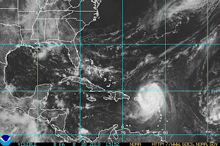
As expected, the NWS has discontinued the Tropical Storm Watch for NE New Jersey as well as NYC.  Tropical Storm Warnings remain in effect, however, for the shore points of NJ and LI.  As you can see from the visible satellite, the cold front has taken over to push Hurricane Earl east and will continue to do so over the next 48 hours at which point Earl will become extratropical over Canada.  Hurricane Earl is currently packing winds of 80 mph and will continue to weaken as it moves just east of Cape Cod and into Nova Scotia.
Elsewhere in the tropics, Tropical Storm Fiona is swiftly approaching Bermuda and will cross the island by Sat morning as a minimal tropical storm.  The remnants of Gaston are entering more favorable conditions and could become a named storm once again.

Labor Day Weekend Outlook 


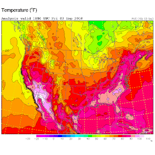
A cold front will pass through the region overnight Friday into Saturday which should bring some showers to the region overnight Friday, as well as cooler temps across the state.  We can see in the image to the left that behind this cold front, temperatures drop to the 70s, 60s, and, in Northern Minnesota and Wisconsin, even the 50s.  Now we won't be seeing temperatures as low as 50's or 60's but by Sunday, high temperatures will be comfortably in the mid 70s, which I'm sure is a welcomed change from the hazy, hot, and humid 90's we've seen the last few days.
For Saturday, expect less-humid, sunny skies with breezy conditions, especially in the northern regions, and temperatures in the low 80s.  Overnight the temperature across the state will drop to the mid 50s.  So be sure to bring a sweatshirt if you're planning to be outside Saturday night.
Sunday will be much of the same with temperatures in the 70's across the state.  Labor Day is shaping up to be a beautiful day across the state as well, with temperatures hovering around 80 degrees with a calm wind and clear skies.

- Meteorologist Anthony Dalbo

Why HELLLOOOO Earl...

Photo courtesy of http://www.ral.ucar.edu/weather/
NWS Radar
Earl is still a Category 2 storm with maximum sustained winds of 105 mph; however, it continues to show signs of weakening.  The storm is still moving to the north-northeast at 18 mph.  Over the next 12-24 hours, Earl should begin to turn more to the northeast and accelerate as he interacts with the approaching cold front to the west.  As of 10AM, Cape May and Atlantic City are reporting wind gusts of only 20 mph out of the north.  As the day wears on and Earl moves closer, conditions are expected to deteriorate with winds gusting to tropical storm force and some tropical rain bands beginning to move into the area.  Last night, as Earl approached the Outer Banks, we noticed a dry slot of air filter into the storm.  This allowed for the NC coast to be spared from a few hours of rain and wind from Earl's outer bands.  That dry slot still exists and is currently over NJ this morning.  Tropical storm force winds are still far reaching with this storm as they can be felt upwards of 205 miles from the center.  That should place NE New Jersey and New York City areas within tropical storm force conditions throughout the afternoon, albeit on the outer fringes.  That is why the NHC has continued the tropical storm watch for the area.  The greater chance of gusty winds will exist for areas south and east of the city.


Frisco Pier, NC (Photo taken by AP)
- Meteorologist Anthony Dalbo

Earl Update: 1:00 AM

Infrared Satellite (courtesy of http://www.ral.ucar.edu/weather/)
Hurricane Earl is continuing to weaken as it moves into cooler ocean waters.  Also to note, Earl has also started to turn more NNE which will take it far enough off the Jersey coastline to make it's impact less severe for the northern regions of the state.  Cape May and Atlantic Counties will still feel the worst of the storm in terms of rain and wind.  Although there will be minimal amounts of rain with Earl, those areas could see winds potentially reaching 40-45 mph during the morning and early afternoon hours when Earl is closest.  The further north you are, the less chance you have of seeing any strong gusty winds.
Again the primary concern is along the coast, as large swells and gusty winds will batter the shoreline causing costly beach erosion and exposing the shore towns to possible flooding.  Unless, Earl shifts to west overnight, which is not expected, the NE portions of the state should see a minimal impact from this storm.
Elsewhere in the Atlantic, Tropical Storm Fiona is weakening as it turns toward Bermuda.  Bermuda is currently under a tropical storm warning as Fiona is forecasted to pass just to the west, if not make landfall, of the island as a minimal tropical storm.
Gaston was forecasted to become a hurricane in a few days; however, he ran into a very dry Saharan air mass and did not survive.  This morning, the convection had diminished and the cluster could not hold together.  As a result, the storm was downgraded to a Tropical Depression and as of 5PM, no more advisories will be made for Gaston.  There is a chance the remnants could reform as it enters the Caribbean but that is still too far out.  Another tropical wave has entered the Atlantic and the NHC is giving this wave a 10% chance to form.  If it does, the next storm will be named Hermine.

- Meteorologist Anthony Dalbo

Thursday, September 2, 2010

Hurricane Earl and the NJ Impact

Hurricane Earl (Courtesy of NHC)
At the 11AM update, Earl has begun to weaken and turn to the north.  Currently, max sustained winds are estimated to be 140 mph, which is lower than the previous advisory.  Considering Earl is entering an area of higher wind shear and cooler temperatures, further weakening should occur over the next 72 hours.  Two things to note in the 11AM advisory is
     1.) an eye wall replacement is expected to occur over the next couple hours and..
     2.) Earl has already turned to an almost northerly direction.

The eye wall replacement is important to note because when this occurs, the wind field will expand.  Currently, hurricane force winds extend outward up to 90 miles from the center and tropical storm force winds extend as far out as 230 miles from the center.  The other fact is that Earl is now moving almost due north (actually 355 degrees). Yesterday, I was anticipating a turn in that direction by later today; however, since it has already turned to the north, Earl should remain offshore as it passes the Outer Banks and remain well off the NJ coast.  The NHC forecast has remained consistent as have the forecast models.  With that said, the "cone of uncertainty" has been trimmed, taking NJ entirely out.  I'll get into the impacts for NJ later in this post.  The current forecast calls for Earl to pass east of the Outer Banks this afternoon, then, as he interacts with the Westerlies, pick up speed and turn NNE as it heads for a potential landfall over Martha's Vineyard and Cape Cod areas.  This path should keep Earl about 100+ miles off the NJ coastline.

NJ Impact


NWS Upton
NWS Philadelphia
Tropical Storm Warnings have been issued from Cape May to Sandy Hook.  Tropical Storm Watches have been issued from Sandy Hook to Clouds will increase from the south this evening as Earl moves closer; however, the strongest winds will be felt primarily along the coastline.  For South Jersey, Cape May and Atlantic Counties could see storm surge as high as 2ft-3ft as Earl passes to the East.  Most, if not all, models are projecting a tight wind/moisture gradient which means the strongest winds and rain will occur along the souther shores and over Long Island/Conn.  For the areas in the watch area, you could encounter minimal tropical storm force winds, especially, if the wind field expands or any tropical rain bands move across the area.  The biggest threat to NJ from Earl will be coastal.  Large waves will cause costly beach erosion all along the coastline as well as coastal flooding.  Northern NJ counties in the watch area (Union, Essex, Bergen, Hudson counties) shouldn't see much if anything in terms of rainfall but could experience periods of tropical storm force winds (35+ mph).

I'll be sure to post an update if there are any changes so keep checking back.

- Meteorologist Anthony Dalbo


Wednesday, September 1, 2010

Hurricane Earl, Tropical Storm Fiona, and now... Tropical Depression 9

Well as the saying goes, "Two's company, three's a crowd." Certainly at this point, the Atlantic is very crowded as we can now add Tropical Depression 9 to the list of storms in the Atlantic, which already includes Hurricane Earl and Tropical Storm Fiona. But before I get to Fiona and TD 9, let me start with Hurricane Earl.
As per the 11AM update, Earl is holding steady at 125 mph sustained winds, making it a Category 3 storm and is moving northwest at 17 mph into an area conducive to further strengthening although most models predict a steady state followed by gradual weakening for him.  The National Weather Service has issued a Hurricane WARNING for the East Coast of the U.S from Bogue Inlet, NC to the NC/Virginia border which includes Pamlico and Albemarle Sounds.  Hurricane WATCHES have been issued from the NC/Virginia border to Cape Henlopen, Delaware, meaning that Hurricane conditions are possible in the watch area and are typically issued 48 hours prior to the occurrence of tropical storm force winds.  Tropical Storm WARNINGS have been issued for areas south of Bogue Inlet, NC to Cape Fear, NC.
Model Outputs (courtesy of Weather Underground)
The High-pressure ridge over the Atlantic, which has been steering the storm WNW is showing signs of retreat, which will allow Earl to begin gradually turning NNW over the next 36 hours.  With that said, I am still looking at the official forecast with cautious skepticism as I feel the models are over-estimating the retreat of the ridge and underestimating the current speed of the storm.  The official forecast calls for Earl to pass just east of the Outer Banks followed by a NNE turn which will keep it off the coastline until making a final landfall in Nova Scotia.  Most of the models support this track; however, it is important to note that these models also predicted Earl to turn to the north before even passing Bermuda.  The point I'm trying to make is that the models are expecting this turn to the north but they don't have a complete grasp on the timing.  One model, NGFDL, which is the Navy's version of the GFDL model, is forecasting a track much further west taking Earl into the Outer Banks and then hugging the coastline before making a second landfall near Islip, NY.  Because this is inconsistent with the other models, the NGFDL has to be dismissed as an anomaly when producing the official forecast; however, it is important to note that track as a possibility.  My opinion is that Hurricane Earl follows a track between the NGFDL (yellow line) and the UKMET (white line), which will take it just east of the Outer Banks and making landfall in Mass. There is a tendency for strong hurricanes like Earl to wobble as they move across the ocean, so any change in position East or West will alter the forecast track.  Therefore, it is important for us in NJ to pay close attention to this storm as it approaches the coastline.

Elsewhere in the Atlantic, we have Tropical Storm Fiona and, now newly named, Tropical Depression 9.  Tropical Storm Fiona is packing 60 mph sustained winds; however, she is not expected to reach hurricane status and is forecasted to remain away from the East Coast but could impact Bermuda early next week.  Tropical Depression 9 is far out east in the Atlantic and is forecasted to reach Tropical storm status by this evening at which time it will be named Gaston.
 - Meteorologist Anthony Dalbo

Monday, August 30, 2010

Hurricane Earl 1pm update.. Category 3

Hurricane Earl (courtesy of NHC)

The National Hurricane Center has released their 11AM update for Hurricane Earl. This morning Hurricane Hunters traveled through Hurricane Earl and found minimum pressure of 960mb with 90KT winds at the Northwest side of the eyewall. That, combined with the latest satellite imagery support an increase of intensity for Earl to Category 3 status.  Maximum sustained winds are estimated to be 120 mph with wind gusts as high as 150 mph. Hurricane Earl is currently centered approximately 160 miles East of San Juan, Puerto Rico and is moving WNW at 14 mph.  
San Juan, PR Radar (courtesy of weatherunderground, wunderground.com)
The outer rain bands have impacted Puerto Rico and latest radar imagery out of San Juan shows the bands around the eye wall just north of St. Thomas.  Puerto Rico should be already experiencing Tropical storm force winds; however, by this evening, much of the island, especially the northern portions should feel hurricane force winds.  Puerto Rico will not feel the full force of Earl as it is expected to remain north of the island; however, they will experience heavy rain, capable of producing flash floods and isolated tornados, as well as damaging winds and storm surge.  
Forecast track (courtesy of NHC)
The forecast for Hurricane Earl calls for a shift to the northwest over the next 24-36 hours. Hurricane Earl is expected to remain East of the US coastline as a trough currently over the Great Lakes makes its way to the East Coast to keep Earl at sea. The models are in pretty good agreement at this time; however, I am concerned that with each run, the models tend to shift the storm further west.  If Hurricane Earl continues it's Westward track for much longer before turning NNW, it could miss the trough all together or combine with the trough too late, causing landfall to occur somewhere along the East Coast.  Days 4 and 5 on the forecast track are highly uncertain at this time for that reason.  If Earl travels too far west before hooking up with the trough, we could see landfall anywhere from NC - Mass as a Category 3 or possibly Category 4 hurricane.  Now keep in mind this is very uncertain, I'm just noting the possibility exists.  It is still very likely that Hurricane Earl will begin his northerly turn over the next day or so and remain out at sea. Even with this solution, the entire East Coast will face impacts such as beach erosion, heavy rain, gusty winds, and coastal flooding which will put a real damper on Labor Day weekend.  

Keep checking this blog for further updates as Hurricane Earl approaches! 

- Meteorologist Anthony Dalbo