Friday, September 3, 2010

Earl Update and Labor Day Weekend Outlook

Visible Satellite
Hurricane Earl
As expected, the NWS has discontinued the Tropical Storm Watch for NE New Jersey as well as NYC.  Tropical Storm Warnings remain in effect, however, for the shore points of NJ and LI.  As you can see from the visible satellite, the cold front has taken over to push Hurricane Earl east and will continue to do so over the next 48 hours at which point Earl will become extratropical over Canada.  Hurricane Earl is currently packing winds of 80 mph and will continue to weaken as it moves just east of Cape Cod and into Nova Scotia.
Elsewhere in the tropics, Tropical Storm Fiona is swiftly approaching Bermuda and will cross the island by Sat morning as a minimal tropical storm.  The remnants of Gaston are entering more favorable conditions and could become a named storm once again.

Labor Day Weekend Outlook 
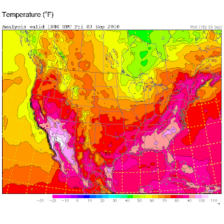

A cold front will pass through the region overnight Friday into Saturday which should bring some showers to the region overnight Friday, as well as cooler temps across the state.  We can see in the image to the left that behind this cold front, temperatures drop to the 70s, 60s, and, in Northern Minnesota and Wisconsin, even the 50s.  Now we won't be seeing temperatures as low as 50's or 60's but by Sunday, high temperatures will be comfortably in the mid 70s, which I'm sure is a welcomed change from the hazy, hot, and humid 90's we've seen the last few days.
For Saturday, expect less-humid, sunny skies with breezy conditions, especially in the northern regions, and temperatures in the low 80s.  Overnight the temperature across the state will drop to the mid 50s.  So be sure to bring a sweatshirt if you're planning to be outside Saturday night.
Sunday will be much of the same with temperatures in the 70's across the state.  Labor Day is shaping up to be a beautiful day across the state as well, with temperatures hovering around 80 degrees with a calm wind and clear skies.

- Meteorologist Anthony Dalbo

Why HELLLOOOO Earl...

Photo courtesy of http://www.ral.ucar.edu/weather/
NWS Radar
Earl is still a Category 2 storm with maximum sustained winds of 105 mph; however, it continues to show signs of weakening.  The storm is still moving to the north-northeast at 18 mph.  Over the next 12-24 hours, Earl should begin to turn more to the northeast and accelerate as he interacts with the approaching cold front to the west.  As of 10AM, Cape May and Atlantic City are reporting wind gusts of only 20 mph out of the north.  As the day wears on and Earl moves closer, conditions are expected to deteriorate with winds gusting to tropical storm force and some tropical rain bands beginning to move into the area.  Last night, as Earl approached the Outer Banks, we noticed a dry slot of air filter into the storm.  This allowed for the NC coast to be spared from a few hours of rain and wind from Earl's outer bands.  That dry slot still exists and is currently over NJ this morning.  Tropical storm force winds are still far reaching with this storm as they can be felt upwards of 205 miles from the center.  That should place NE New Jersey and New York City areas within tropical storm force conditions throughout the afternoon, albeit on the outer fringes.  That is why the NHC has continued the tropical storm watch for the area.  The greater chance of gusty winds will exist for areas south and east of the city.


Frisco Pier, NC (Photo taken by AP)
- Meteorologist Anthony Dalbo

Earl Update: 1:00 AM

Infrared Satellite (courtesy of http://www.ral.ucar.edu/weather/)
Hurricane Earl is continuing to weaken as it moves into cooler ocean waters.  Also to note, Earl has also started to turn more NNE which will take it far enough off the Jersey coastline to make it's impact less severe for the northern regions of the state.  Cape May and Atlantic Counties will still feel the worst of the storm in terms of rain and wind.  Although there will be minimal amounts of rain with Earl, those areas could see winds potentially reaching 40-45 mph during the morning and early afternoon hours when Earl is closest.  The further north you are, the less chance you have of seeing any strong gusty winds.
Again the primary concern is along the coast, as large swells and gusty winds will batter the shoreline causing costly beach erosion and exposing the shore towns to possible flooding.  Unless, Earl shifts to west overnight, which is not expected, the NE portions of the state should see a minimal impact from this storm.
Elsewhere in the Atlantic, Tropical Storm Fiona is weakening as it turns toward Bermuda.  Bermuda is currently under a tropical storm warning as Fiona is forecasted to pass just to the west, if not make landfall, of the island as a minimal tropical storm.
Gaston was forecasted to become a hurricane in a few days; however, he ran into a very dry Saharan air mass and did not survive.  This morning, the convection had diminished and the cluster could not hold together.  As a result, the storm was downgraded to a Tropical Depression and as of 5PM, no more advisories will be made for Gaston.  There is a chance the remnants could reform as it enters the Caribbean but that is still too far out.  Another tropical wave has entered the Atlantic and the NHC is giving this wave a 10% chance to form.  If it does, the next storm will be named Hermine.

- Meteorologist Anthony Dalbo

Thursday, September 2, 2010

Hurricane Earl and the NJ Impact

Hurricane Earl (Courtesy of NHC)
At the 11AM update, Earl has begun to weaken and turn to the north.  Currently, max sustained winds are estimated to be 140 mph, which is lower than the previous advisory.  Considering Earl is entering an area of higher wind shear and cooler temperatures, further weakening should occur over the next 72 hours.  Two things to note in the 11AM advisory is
     1.) an eye wall replacement is expected to occur over the next couple hours and..
     2.) Earl has already turned to an almost northerly direction.

The eye wall replacement is important to note because when this occurs, the wind field will expand.  Currently, hurricane force winds extend outward up to 90 miles from the center and tropical storm force winds extend as far out as 230 miles from the center.  The other fact is that Earl is now moving almost due north (actually 355 degrees). Yesterday, I was anticipating a turn in that direction by later today; however, since it has already turned to the north, Earl should remain offshore as it passes the Outer Banks and remain well off the NJ coast.  The NHC forecast has remained consistent as have the forecast models.  With that said, the "cone of uncertainty" has been trimmed, taking NJ entirely out.  I'll get into the impacts for NJ later in this post.  The current forecast calls for Earl to pass east of the Outer Banks this afternoon, then, as he interacts with the Westerlies, pick up speed and turn NNE as it heads for a potential landfall over Martha's Vineyard and Cape Cod areas.  This path should keep Earl about 100+ miles off the NJ coastline.

NJ Impact


NWS Upton
NWS Philadelphia
Tropical Storm Warnings have been issued from Cape May to Sandy Hook.  Tropical Storm Watches have been issued from Sandy Hook to Clouds will increase from the south this evening as Earl moves closer; however, the strongest winds will be felt primarily along the coastline.  For South Jersey, Cape May and Atlantic Counties could see storm surge as high as 2ft-3ft as Earl passes to the East.  Most, if not all, models are projecting a tight wind/moisture gradient which means the strongest winds and rain will occur along the souther shores and over Long Island/Conn.  For the areas in the watch area, you could encounter minimal tropical storm force winds, especially, if the wind field expands or any tropical rain bands move across the area.  The biggest threat to NJ from Earl will be coastal.  Large waves will cause costly beach erosion all along the coastline as well as coastal flooding.  Northern NJ counties in the watch area (Union, Essex, Bergen, Hudson counties) shouldn't see much if anything in terms of rainfall but could experience periods of tropical storm force winds (35+ mph).

I'll be sure to post an update if there are any changes so keep checking back.

- Meteorologist Anthony Dalbo


Wednesday, September 1, 2010

Hurricane Earl, Tropical Storm Fiona, and now... Tropical Depression 9

Well as the saying goes, "Two's company, three's a crowd." Certainly at this point, the Atlantic is very crowded as we can now add Tropical Depression 9 to the list of storms in the Atlantic, which already includes Hurricane Earl and Tropical Storm Fiona. But before I get to Fiona and TD 9, let me start with Hurricane Earl.
As per the 11AM update, Earl is holding steady at 125 mph sustained winds, making it a Category 3 storm and is moving northwest at 17 mph into an area conducive to further strengthening although most models predict a steady state followed by gradual weakening for him.  The National Weather Service has issued a Hurricane WARNING for the East Coast of the U.S from Bogue Inlet, NC to the NC/Virginia border which includes Pamlico and Albemarle Sounds.  Hurricane WATCHES have been issued from the NC/Virginia border to Cape Henlopen, Delaware, meaning that Hurricane conditions are possible in the watch area and are typically issued 48 hours prior to the occurrence of tropical storm force winds.  Tropical Storm WARNINGS have been issued for areas south of Bogue Inlet, NC to Cape Fear, NC.
Model Outputs (courtesy of Weather Underground)
The High-pressure ridge over the Atlantic, which has been steering the storm WNW is showing signs of retreat, which will allow Earl to begin gradually turning NNW over the next 36 hours.  With that said, I am still looking at the official forecast with cautious skepticism as I feel the models are over-estimating the retreat of the ridge and underestimating the current speed of the storm.  The official forecast calls for Earl to pass just east of the Outer Banks followed by a NNE turn which will keep it off the coastline until making a final landfall in Nova Scotia.  Most of the models support this track; however, it is important to note that these models also predicted Earl to turn to the north before even passing Bermuda.  The point I'm trying to make is that the models are expecting this turn to the north but they don't have a complete grasp on the timing.  One model, NGFDL, which is the Navy's version of the GFDL model, is forecasting a track much further west taking Earl into the Outer Banks and then hugging the coastline before making a second landfall near Islip, NY.  Because this is inconsistent with the other models, the NGFDL has to be dismissed as an anomaly when producing the official forecast; however, it is important to note that track as a possibility.  My opinion is that Hurricane Earl follows a track between the NGFDL (yellow line) and the UKMET (white line), which will take it just east of the Outer Banks and making landfall in Mass. There is a tendency for strong hurricanes like Earl to wobble as they move across the ocean, so any change in position East or West will alter the forecast track.  Therefore, it is important for us in NJ to pay close attention to this storm as it approaches the coastline.

Elsewhere in the Atlantic, we have Tropical Storm Fiona and, now newly named, Tropical Depression 9.  Tropical Storm Fiona is packing 60 mph sustained winds; however, she is not expected to reach hurricane status and is forecasted to remain away from the East Coast but could impact Bermuda early next week.  Tropical Depression 9 is far out east in the Atlantic and is forecasted to reach Tropical storm status by this evening at which time it will be named Gaston.
 - Meteorologist Anthony Dalbo