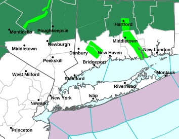
As I mentioned at the top, the heavier rain bands have begun to push through the region and some of these bands are producing TORNADOS. North NJ can expect much of the same over the next couple of hours. Between 1AM-5AM, tropical storm force sustained winds between 30-60mph will be wide spread throughout the region with higher wind gusts located in heavier rain bands. Around 5AM, Irene's core will be close enough to bring us hurricane force sustained winds ranging upwards near 80mph. That will last until 10AM, at which point, the winds will begin to gradually subside.
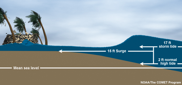
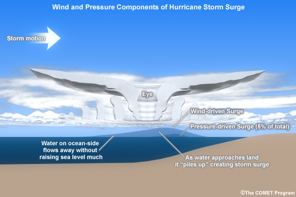
 Flooding is the other concern. Reports at this early hour of the storm are coming in from Newark and Jersey City of street flooded. Because of the saturated rain, it was estimated that only 2" of rain would be needed to flood much of NJ and we are already at that point. Forecasted rain totals throughout NJ are between 8"-12". Widespread flooding is expected and that's not including the storm surge and storm tide levels along the coast. Storm surge forecasts are calling for 4'-8' from Cape May to Long Island Sound. Raritan Bay can expect 6' storm surges; Battery Park can expect 5' storm surge; and Atlantic City could see storm surge of around 8'. Water levels rising 4'-6' plus another 2'-4' associated with the New Moon Tide gives us a storm tide range of 6'-10'. So imagine the water levels along the coastal regions rising 6'-10' plus 10'-15' waves crashing above that! This is a very serious threat to public and property so if you decided to stay along the coast and not heed the evacuation orders, climb as high as you can and hope for the best.
 As long as you have power, please keep watch for tornado warnings posted for your area and stay away from windows in case any debris gets whipped around. Also, for those living near tall trees, I suggest staying in a lower level of your house, in case a tree falls. If you happen to lose power, which much of us will, please refrain from using candles! Candles present a severe fire threat and emergency vehicles will not be out to help during the peak of the storm. With that said, I wish you all the best.