 |
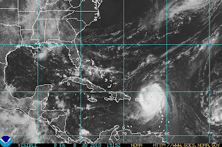
| Hurricane Earl (courtesy of NHC) |
The National Hurricane Center has released their 11AM update for Hurricane Earl. This morning Hurricane Hunters traveled through Hurricane Earl and found minimum pressure of 960mb with 90KT winds at the Northwest side of the eyewall. That, combined with the latest satellite imagery support an increase of intensity for Earl to Category 3 status. Maximum sustained winds are estimated to be 120 mph with wind gusts as high as 150 mph. Hurricane Earl is currently centered approximately 160 miles East of San Juan, Puerto Rico and is moving WNW at 14 mph.
 |
| San Juan, PR Radar (courtesy of weatherunderground, wunderground.com) |
The outer rain bands have impacted Puerto Rico and latest radar imagery out of San Juan shows the bands around the eye wall just north of St. Thomas. Puerto Rico should be already experiencing Tropical storm force winds; however, by this evening, much of the island, especially the northern portions should feel hurricane force winds. Puerto Rico will not feel the full force of Earl as it is expected to remain north of the island; however, they will experience heavy rain, capable of producing flash floods and isolated tornados, as well as damaging winds and storm surge.
 |
| Forecast track (courtesy of NHC) |
The forecast for Hurricane Earl calls for a shift to the northwest over the next 24-36 hours. Hurricane Earl is expected to remain East of the US coastline as a trough currently over the Great Lakes makes its way to the East Coast to keep Earl at sea. The models are in pretty good agreement at this time; however, I am concerned that with each run, the models tend to shift the storm further west. If Hurricane Earl continues it's Westward track for much longer before turning NNW, it could miss the trough all together or combine with the trough too late, causing landfall to occur somewhere along the East Coast. Days 4 and 5 on the forecast track are highly uncertain at this time for that reason. If Earl travels too far west before hooking up with the trough, we could see landfall anywhere from NC - Mass as a Category 3 or possibly Category 4 hurricane. Now keep in mind this is very uncertain, I'm just noting the possibility exists. It is still very likely that Hurricane Earl will begin his northerly turn over the next day or so and remain out at sea. Even with this solution, the entire East Coast will face impacts such as beach erosion, heavy rain, gusty winds, and coastal flooding which will put a real damper on Labor Day weekend.
Keep checking this blog for further updates as Hurricane Earl approaches!
- Meteorologist Anthony Dalbo